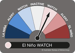
 The Bureau of Meteorology has updated its Outlook Dial for the El Niño effect to impact on Australia’s weather patterns down from ‘Alert’ to ‘Watch’.
In a statement the Bureau said that at present, sea surface temperatures in the tropical Pacific remained close to El Niño levels, but water beneath the surface had slowly cooled over the past few months.
“Atmospheric conditions have also remained neutral, despite short-term El Niño-like conditions,” the Bureau said.
“International models surveyed by the Bureau indicate the sea surface temperatures in the tropical Pacific Ocean are likely to remain close to El Niño thresholds until mid-winter, before cooling in late winter to spring.”
It said that by August, two of the eight models were clearly at El Niño levels, another two near El Niño thresholds, and the remaining models neutral.
“An El Niño typically brings drier than average conditions to eastern Australia during winter-spring, and warmer days across the southern two-thirds of the country,” the Bureau said.
“The Indian Ocean Dipole, one of Australia’s other main climate drivers, remains neutral, but the majority of international models surveyed by the Bureau indicate a positive Indian Ocean Dipole event is likely to develop in winter.”
The Bureau said a positive Indian Ocean Dipole typically meant below average winter-spring rainfall for much of southern and central Australia.