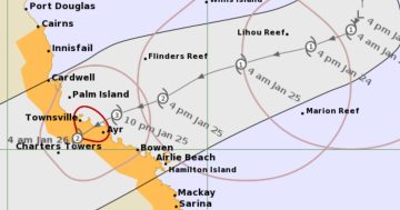
The predicted tracking map of Future Tropical Cyclone Kirrily as of 10:50 am Wednesday (24 January) morning. Image: BoM.
The slow-moving low-pressure system sitting off the north Queensland coast has been further downgraded according to the Bureau of Meteorology.
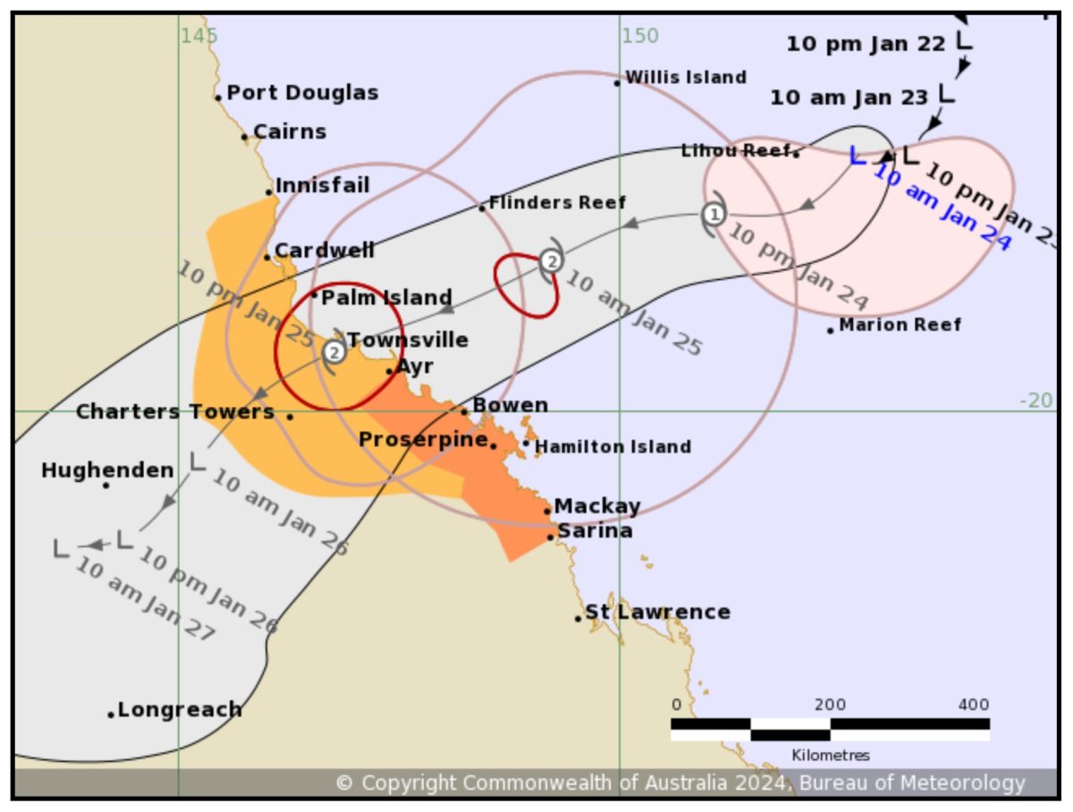
As of 5 am this morning (24 January), the system had still not developed into a cyclone, and was lingering about 700 km east-northeast of Townsville and moving west-southwest at 7 km/h.
The low is currently generating winds of 75 km/h with wind gusts up to 95 km/h, and the BoM predicts it will continue to intensify and generate into a cyclone sometime Wednesday afternoon.
Previous forecasts that it would cross the coast between Townsville and Ayr as a Category 3 cyclone late on Thursday night have been revised. While the predicted timings remain the same, Future Tropical Cyclone Kirrily is now likely to only reach a Category 2 level, and its predicted track is now centred directly on Townsville.
The areas expected to be affected by storm tides remain low-lying coastal regions between Townsville and Mackay, with the worst wind gusts expected to be felt on the southern side of the storm between Townsville and the Whitsundays region.
Gales with damaging wind gusts of 120 km/h are likely to develop about the Whitsunday Islands as early as Wednesday evening. These gales may extend to communities between Ayr and Sarina early Thursday morning, and northward to communities between Ayr and Cardwell including Townsville during Thursday.
Further north, gales and damaging wind gusts of 90 km/h may be experienced between Cardwell and Innisfail, and inland to Charters Towers overnight Thursday night or Friday.
Destructive wind gusts of up to 155 km/h may develop about coastal and island communities between Cardwell and Proserpine including Townsville and the Whitsunday Islands during Thursday.
Also of concern is forecast flash-flooding which will likely be experienced in coastal areas between Innisfail and Sarina from early Thursday, before spreading to inland areas later during Thursday and continuing during Friday.
By Friday the system is expected to become a tropical low and heavy rainfall is expected across central, western and southern Queensland into the weekend as the system tracks inland and then south.