 Melbourne Water is to fast-track new flood modelling across Melbourne due to the impacts of climate change and an evolving urban landscape combined with new standards.
The Managing Director of Melbourne Water, Nerina Di Lorenzo said the modelling work, which commenced in 2021, would re-map the Port Phillip and Western Port Catchments to incorporate climate change projections to 2100 by 2026.
“Extreme flood events are expected to become more likely as our climate changes over the coming decades,” Dr Di Lorenzo said.
“We have an opportunity now to enhance Melbourne’s future resilience,” she said.
“This relies on having flood information that takes future projections into account, and ensuring this is readily available so authorities and communities can plan ahead.”
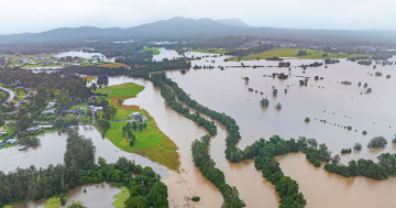
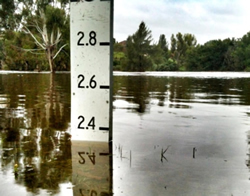
Dr Di Lorenzo said the October 2022 flood event impacted properties in Brimbank, Maribyrnong, Melbourne and Moonee Valley and a review of the flood models for those areas was ongoing.
She said that in any given year it was estimated that over 200,000 properties across Melbourne Water’s region had at least a one per cent chance of flooding.
“This is why we have been running a program to incorporate climate impacts to the year 2100 into our flood maps and models for every catchment in Melbourne,” she said.
“Building these models is a very long and detailed process and we are accelerating that program,” Melbourne Water’s Managing Director said.
“Completing this by 2026 means housing and infrastructure that is built in the coming 70 years will be more flood ready for the future,” she said.