 The Department of Agriculture has launched a new mapping upgrade on its More To Explore app to help Victorian hunters identify areas where they can legally hunt.
The Minister for Agriculture, Jaclyn Symes launched the new maps on the already popular app, which has been used by more than 20,000 people to navigate 3.9 million hectares of public land.
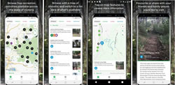
“The app is Victoria’s first comprehensive electronic mapping system showing all public land available for hunters,” Ms Symes said.
“As well as which species of both game animals and pests can be hunted in specific areas,” she said.
“The maps [are] also available for download to use offline or out of mobile range.”
Ms Symes said that with more than 50,000 licensed hunters in the State, clearly labelling hunting areas was an important step towards ensuring hunters stayed within legal boundaries.
“The app is regularly updated to reflect changes in land status and show road closures and also features an emergency location function for public land users’ safety,” she said.
She said the app was useful for more than just hunters as it provided comprehensive information on State Forest camping sites, bushwalking and mountain bike trails, 4WD tracks and seasonal road closures.
Ms Symes said More To Explore was available from the iOS App Store and the Google Play store.