 Geoscience Australia has completed an airborne electromagnetic survey across western Victoria as part of its Exploring for the Future Program.
The Department of Jobs, Precincts and Regions said the Program Survey was gathering data about the potential groundwater, mineral and energy resources beneath the surface.
“After a successful four-year Program in northern Australia, the Program is focussing on the southern half of the continent,” the Department said.
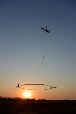
“Airborne electromagnetic surveying involves using light aircraft fitted with specialist equipment to map variations in the electrical conductivity of the ground to a depth of several hundred metres,” it said.
“Flying about six hours per day in lines spaced 20 kilometres apart, the Survey travelled almost 5,000km to analyse 98,200 square kilometres of ground in Victoria and provide an overview of the region’s geological potential.”
The Department said data collected during the three-week Survey would be publicly available from September and the information gathered could help inform resource management and investment decisions.
Geoscience Australia said its Exploring for the Future Program aimed to drive investment in the resources and agricultural sectors by providing industry and land and water managers with pre-competitive data about potential mineral, energy and groundwater resources.
Further information on the Geoscience Australia Program can be accessed at this PS News link.


