The Department of Transport’s Regional Roads Victoria (RRV) is trialling new technology to deliver its regional road maintenance blitz more efficiently and with better results.
Announced by Minister for Roads and Road Safety, Ben Carroll, the Agency is testing artificial intelligence (AI) software in the State’s north-east with car-mounted cameras and trialling the use of small drones to capture footage of difficult-to-reach locations in the State’s west.
Mr Carroll said the AI software and vehicle-mounted cameras would help map and assess the condition of more than 4,000 kilometres of arterial roads and roadside assets.
“The software has used footage captured by vehicle-mounted cameras to automatically detect, categorise and assess the condition of more than 160,000 individual road assets, including signs, line marking, trees and safety barriers, as well as the road surface itself,” he said.
“This allows the crews in charge of managing these assets to better understand the network’s current state and allocate funding and resources where they are needed most.
“Using this groundbreaking software will map the thousands of kilometres of road sections in a matter of weeks – a fraction of time compared to traditional methods that would take around three years to collect and assess.”
Mr Carroll said the new technology also meant inspectors no longer needed to leave their vehicles and could instead travel at the speed of the traffic, “making significant improvements in safety and effective use of time”.
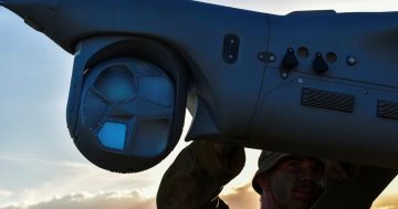
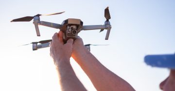
The Minister said RRV’s drone trial in the State’s west involved the use of high-resolution cameras mounted on small drones to capture footage from hard-to-reach or dangerous locations, including underneath bridges as well as sound walls and storm barriers on busy freeways.
“The high-definition images captured by the drones depict even the most minute details, such as hairline cracks, and remove the need for staff to use boats or work at heights to carry out these inspections,” he said.
Mr Carroll said the drones had also been used in recent emergencies to provide engineers with a bird’s-eye view of the damage caused by storms and bushfires, which assisted with planning for clean-up and repair works.