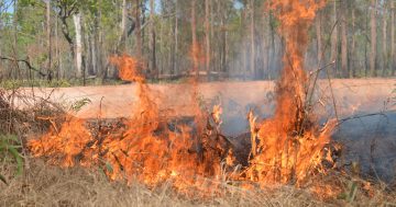
 Scientists from the Department of Environment and Science (DES) have developed a better way of using satellite imagery to map where fires have occurred in Queensland.
The initiative, in partnership with the Joint Remote Sensing Research Program, is expected to greatly improve the State’s fire management capabilities.
Minister for Science, Meaghan Scanlon said Queensland’s diverse landscapes, vegetation and soil types, combined with the effects of cloud, smoke and other landscape dynamics, made it challenging to accurately map burned areas using satellite imagery.
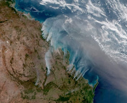
“This new methodology uses the European Space Agency’s high-frequency Sentinel-2 satellite imagery, combined with machine learning and specialised operational mapping technology, to produce high quality State-wide maps of areas impacted by fire every month,” Ms Scanlon said.
“With two identical satellites in orbit, the Sentinel-2 mission captures imagery for all parts of Queensland every five days, meaning the regularity of the monitoring will be frequent enough to capture most fires as they occur, providing a resource that will complement active fire maps,” she said.
Ms Scanlon said the new maps detailed the extent and changes in burnt areas in a way that could be easily used by land managers and Agencies such as the Queensland Parks and Wildlife Service and Queensland Fire and Emergency Service (QFES).
“Understanding exactly where and when a fire has occurred will help us to improve our predictive fire modelling capabilities and assist in the development of planned burn or hazard reduction programs,” she said.
“It will allow us to monitor the ecological impacts of fire on biodiversity, land condition, water and air quality, and better quantify our greenhouse gas emissions.”
Commissioner for QFES, Greg Leach said the new product had already proven to be an important tool.
“It is a key component of QFES’s fire history data set, which is used to inform our fire modelling technology and predictions as they occur by considering the available fuel on that landscape for the fire to consume,” Commissioner Leach said.
“Knowing what areas have burnt previously also provides crucial hazard-reduction burn considerations as we work with our partners, including the community, to mitigate the risk of bushfires,” he said.